 Schematic Illustration
Abstract
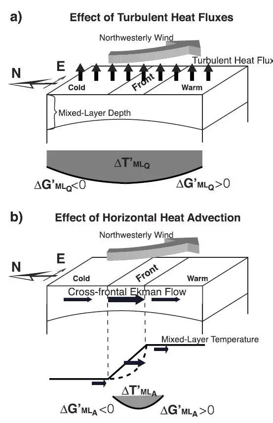
The response of the subpolar front in the Sea of Japan (also known as the East Sea) to winter cyclones is investigated based on quantitative analyses of gridded and satellite data sets. Cyclone passages affecting the sea are detected using time series of spatially averaged surface turbulent heat fluxes. As the cyclones develop, there are strong cold-air outbreaks that produce twice the normal heat loss over the sea. After removal of sea surface temperature (SST) seasonal trends, we found that cyclone passage (hence, cooling) mainly occurred over 3 days, with maximum SST reduction of −0.4°C. The greatest reduction was found along the subpolar front, where frontal sharpness (i.e., SST gradient) increased by 0.1°C (100 km)−1. Results of a mixed-layer model were consistent with both temperature and frontal sharpness, and localized surface cooling along the subpolar front resulted from both horizontal heat advection and turbulent heat fluxes at the sea surface. Further analyses show that this localized cooling from horizontal heat advection is caused by the cross-frontal Ekman flow (vertically averaged over the mixed layer) and strong northwesterly winds associated with the cold-air outbreak during cyclone passage.